Chicago Weather: Temperatures expected to drop again as major winter storm brings freezing rain, strong winds


CHICAGO (WLS) -- Almost 300 flights were canceled at Chicago's airports Saturday, as a major winter storm hit the city and suburbs.
After dumping snow on the Chicago area, precipitation was expected to turn into rain overnight.
Winnetka resident Tim Ring wanted to get ahead of the rain by shoveling Saturday.
"It's half snow, half water. So it's heavy and it's messy. It's like shoveling mashed potatoes," Ring said.
That was bad news for Ring's cleanup, but his daughter Kate liked the snow for the igloo she was building with her sister, Amelia.
"It's much more crunch, and it's easier to be packed into a ball or a brick," Kate said.
The snow on the ground was much slushier, too, creating puddles on local roads and leaving walkways slippery.
"I heard it last night, and I knew it was going to be a bear this morning," Deerfield resident Steve Markoff said.
But Markoff knew he needed to act fast, with temperatures plummeting Saturday afternoon, freezing whatever is left unshoveled.
Ring said it seemed local crews were acting quickly, as well.
"The sidewalks are done, the alleys are done, the streets are done so I think they know that there's a pretty good sense of urgency to get it cleaned up before it gets really cold," Ring said. "We're doing a little salt and just making sure it's clean and ready for the hard freeze."
A Winter Weather Advisory was in effect for Cook, DuPage, Ford, Grundy, Iroquois, Kane, Kankakee, Kendall, Lake, La Salle, Livingston, and Will counties in Illinois and Benton, Jasper, Lake, Newton and Porter counties in Indiana until 6 a.m. Saturday. The advisory extends until 9 a.m. Saturday for La Porte and Starke counties in Indiana, and until 6 p.m. for Boone, De Kalb, Lee, McHenry, Ogle and Winnebago counties in Illinois and Walworth, Kenosha and Racine counties in Wisconsin.
The National Weather Service issued a Wind Chill Advisory from 9 p.m. Saturday to 10 a.m. Sunday for Boone, DeKalb, Kane, Kendall, LaSalle, Lee, Livingston, McHenry, Ogle and Winnebago counties. Wind chills as low as 20 below zero are expected.
The city of Chicago advised residents to keep a trickle of water running to avoid frozen pipes.
The South Shore Line plans to provide substitute buses between South Bend and Michigan City Carroll Avenue for two trains Sunday, in response to the forecast. The busing will affect only WB Tr 502, departing South Bend at 7:45 a.m. ET, and WB Tr 504, departing South Bend at 9:01 a.m. ET. Trains EB Tr 701 and Tr 703 are canceled. Tr 502 and Tr 504 passengers should be prepared to board buses immediately north of the South Shore platform at the South Bend International Airport, and re-board South Shore trains at Carroll Ave.
Snow piled up across the area Friday evening, with areas like Buffalo Grove and Cary reporting at least 4 inches of accumulation by 10 p.m. Snow will continue falling late Friday and could be heavy at times, ABC7 meteorologist Cheryl Scott said.
Between 2-5 inches of snow are expected from the south suburbs to the city Friday night, with higher totals of between 3-6 inches across the northern suburbs. Areas south of the city may see accumulations from 1-3 inches. The snow will change over in the overnight hours into Saturday, Scott said.
On Saturday, the Chicago area can expect rain changing back over to freezing rain or snow with some light additional accumulations. Ice accumulations of up to one-tenth to one-quarter inch are possible with the highest amounts south of Interstate 80. The system is expected to move out by Saturday afternoon.
WATCH: Storm hits during rush hour, leading to dangerous driving
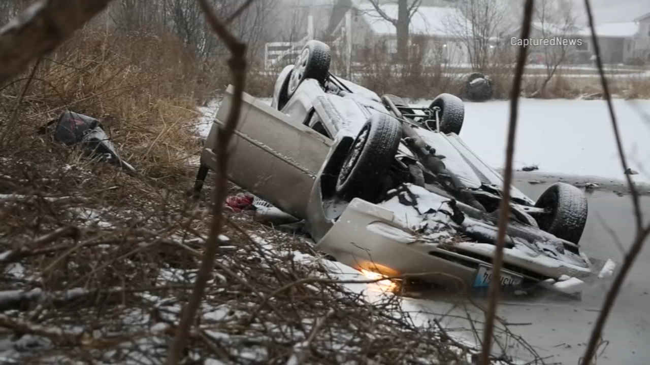
The storm made for treacherous travel across the Chicago area Friday evening. A car slid off the road in north suburban Woodstock and was upside-down and partly underwater, though the driver and his passenger managed to escape unhurt.
Friday, nearly 700 flights were canceled at O'Hare and over 150 flights canceled at Midway due to weather. A ground stop was in effect at O'Hare for all arriving flights for several hours Friday night.
The City of Chicago deployed 287 snow vehicles to help keep Lake Shore Drive and arterial roads clear. With the snow hitting right before rush hour, there was little salt truck drivers could do to prepare the roads.
The Lake Shore Lakefront Trail is closed between Oak Street and Ohio Street due to waves and icy conditions, the city said in an alert about noon Friday.
RELATED: Winter storm wreaks havoc along Chicago's lakefront

The winter weather comes roughly a week after powerful winds, waves and heavy rain pounded the Chicago lakefront last weekend. Some homes and trails along the lakefront are in need of repairs after Lake Michigan's high waves spilled onto city streets.
Last weekend, the winter storm canceled more than 1,200 flights at Chicago airports.
RELATED: Falling ice shatters car window near former John Hancock building in Streeterville


