Chicago Weather: Tornado touched down in Coal City, NWS says


CHICAGO (WLS) -- At least one person was seriously injured as severe storms with five reported tornadoes ripped across the Chicago area Monday night. The National Weather Service confirmed at least one tornado touched down in Coal City, Illinois.
PHOTOS: Storm damage reported across Chicago area
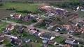
Coal City Police Sgt. Thomas Logan said the tornado damaged numerous residences, but there were no known injuries and no fatalities. He said the tornado formed near Coal City High School and moved southeast through the primarily residential west side of the city, south of the Burlington Northern tracks and out of town.
Fire Station No. 2 was struck by lightning, which caused a communications tower to fall on the building. All fire trucks have been moved out of the damaged building.
The Coal City Fire Protection District said in a statement said that there are also downed power lines throughout the area, natural gas leaks to many homes and heavy flooding of roadways making much of the area impassable. The Coal City area is under restricted access and officials are asking everyone stay out of the area unless absolutely necessary.
An emergency shelter has been established at the Coal City High School at 650 West Division Street for residents in need. The Red Cross has also set up shelters in Coal City and Sublette to help residents with home damage.
Fire department personnel, outside agency personnel and area police, including first responders from Will and Grundy counties and Illinois State Police, are working to assess injuries and damage.
VIDEO: Power lines down across I-55 near Reed Rd.

All lanes of I-55 are blocked near Reed Rd. after high tension power lines from the Braidwood nuclear plant were downed across the interstate, police said. No injuries have been confirmed at this time.
VIDEO: Officials discuss damage at Woodhaven Lakes

At 8:10 p.m., a weather spotter reported a tornado was located southeast of the village of Sublette in Lee County. There were reports of multiple people trapped at Woodhaven Lakes camp and mobile home complex, just west of Sublette.
"We were hit with damaging winds, we're not sure if it was a tornado at this time. It was either straight-line winds or a tornado," said Sublette Fire Dept. Asst. Chief Kevin Schultz.
Schultz said that one person at Woodhaven Lakes was seriously injured and taken to an area hospital, and several others were treated at the scene. No fatalities have been confirmed at this time.
"Everything south of 30 got hit much harder than everything north of 30. So we're talking about the Harmon, Amboy, Sublette, and of course, Woodhaven Lakes areas. We had a report of one possible touchdown of a tornado outside of Sublette that took down a barn, no injuries," Lee County Sheriff John Simonton said.
VIDEO: Power outages, storm damage in Mendota, Ill.

Just after 8 p.m., a tornado was reported east of Mendota, Ill. ABC7 Facebook fan Evaristo Rosalez shared this video of a funnel cloud near Mendota.
"I watched it come over the Mendota High School, going up U.S. Highway 52. I was heading in towards Mendota to get back home from Sterling, Illinois, and all of a sudden I watched it touch down, so I hurried and got to shelter," Rosalez said.
VIDEO: Partial building collapse at Northwood Mall in Sterling, Ill.

Damage has also been reported in Sterling, Ill., where a partial collapse and flooding has been reported at Northland Mall. Sterling police confirmed heavy building damage and downed wires in the area, but are not aware of any injuries.
ComEd said 26,000 customers are without power as of 12:30 a.m., mostly in the Dixon and Sterling area. About 5,000 customers are without power in the Joliet area, ComEd said.
A Tornado Watch has been extended for Kankakee and Will counties in Illinois, and Porter and Lake counties in Indiana until 2 a.m. CDT.
A Watch means a storm with large hail and damaging winds is possible due to the conditions, while a Warning indicates a storm has formed and is approaching. During a warning, residents should seek shelter.
If you are in the path of the storm, take cover in a basement or an interior room on the lowest floor of a sturdy building and avoid windows. If you are outdoors, in a mobile home or a vehicle, move to the closest substantial shelter and protect yourself from flying debris.
WIND, LIGHTNING DAMAGE REPORTED ACROSS CHICAGO AREA
The first round of storms brought lightning and high winds into the Chicago area early Monday afternoon. Wind damage was reported in Yorkville, Joliet and the Ukrainian Village neighborhood in Chicago.
In north suburban Buffalo Grove, a lightning strike damaged a home just after noon. Energy from the lightning is believed to have traveled underground along electrical wiring near a tree to the homeowners' electrical system.
"Huge explosion. It shook your body, and I would say within 20 seconds I was out of the house. As soon as I saw the smoke in the garage, I ran out," said homeowner Jaime Goldstein.
Crews secured shattered windows and the garage after firefighters extinguished smoldering insulation.
"The garage is damaged. It goes up the house to the upstairs bedroom. We have windows shattered out. We have flooding in the basement from the house," Goldstein said.
No one was injured, but the homeowners are unable to stay in the home until the damage is repaired.
In the extreme northwest corner of Illinois, strong winds destroyed a small fire station in East Dubuque. Two vehicles inside the station were crushed when the roof collapsed, but no one was injured.