

AccuWeather


- Severe Thunderstorm Watch
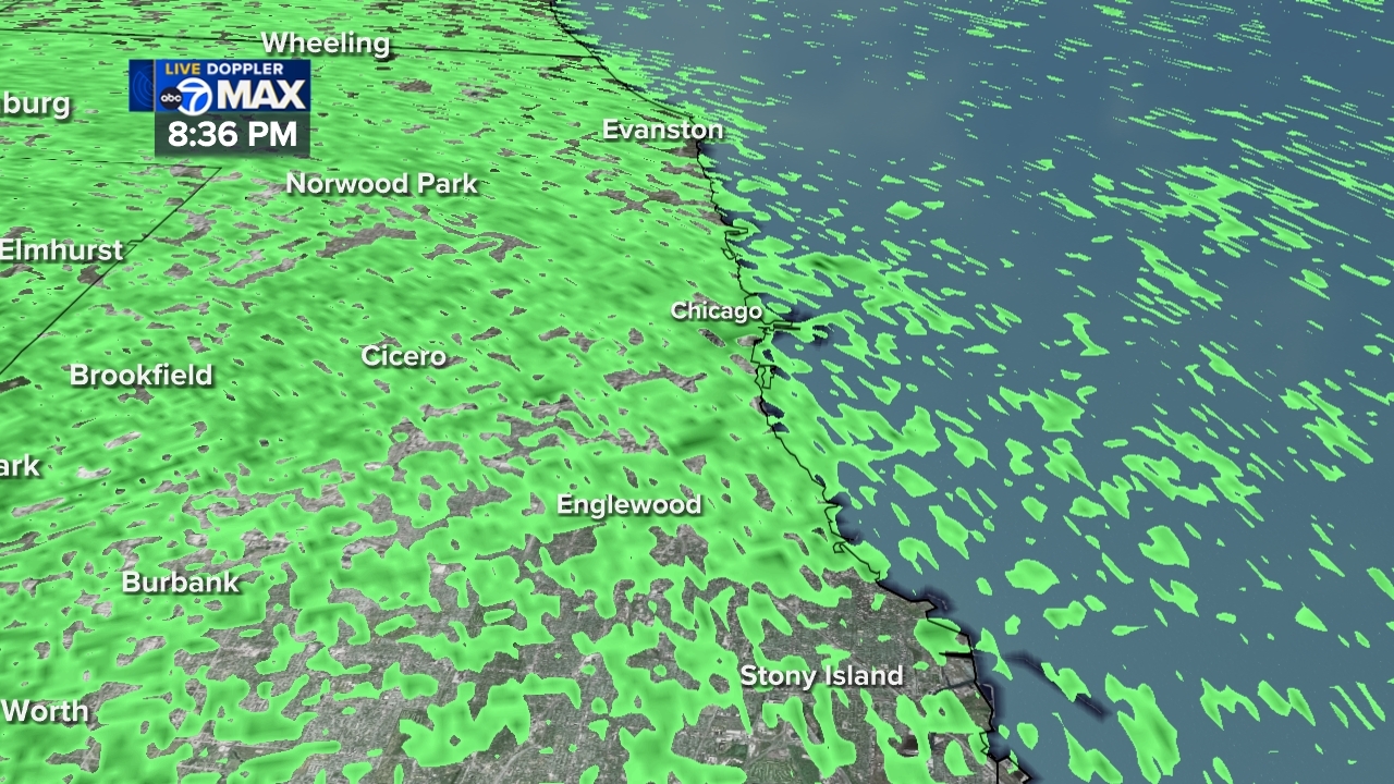
SEVERE THUNDERSTORM WATCH 520 REMAINS VALID UNTIL 7 PM CDT /8 PM EDT/ THIS EVENING FOR THE FOLLOWING AREAS IN ILLINOIS THIS WATCH INCLUDES 3 COUNTIES IN EAST CENTRAL ILLINOIS IROQUOIS IN NORTHEAST ILLINOIS KANKAKEE WILL IN INDIANA THIS WATCH INCLUDES 4 COUNTIES IN NORTHWEST INDIANA BENTON JASPER LAKE IN NEWTON THIS INCLUDES THE CITIES OF BOLINGBROOK, BOURBONNAIS, DEMOTTE, FOWLER, GARY, GILMAN, HAMMOND, JOLIET, KANKAKEE, KENTLAND, MERRILLVILLE, MOROCCO, OXFORD, RENSSELAER, ROSELAWN, WATSEKA, AND WILMINGTON.More
- Flood Warning
...The National Weather Service in Chicago IL has issued a Flood Warning for the following rivers in Illinois...Indiana... Little Calumet River at Munster (Hohman Avenue) affecting Cook and Lake IN Counties. For the Little Calumet River...including Munster (Hohman Avenue)... Minor flooding is forecast. * WHAT...Minor flooding is forecast. * WHERE...Little Calumet River from IN-912 in Hammond downstream to confluence with Thorn Creek in South Holland, including the Munster (Hohman Avenue) gauge. * WHEN...Until early tomorrow afternoon. * IMPACTS...At 12.5 feet, Most areas outside of the levee-protected area are inundated in Hammond and Munster. * ADDITIONAL DETAILS... - At 2:00 PM CDT Monday the stage was 9.3 feet. - The river has begun rising quickly due to earlier heavy rainfall. - Forecast...The river is expected to rise above flood stage by this evening and crest near 12.5 feet late this evening. - Flood stage is 12.0 feet. - http://www.weather.gov/safety/floodMore
- Extreme Heat Warning
* WHAT...Dangerously hot conditions with heat index values up to 113. * WHERE...Livingston, Boone, De Kalb, La Salle, Lee, Ogle, and Winnebago Counties. * WHEN...Until 9 PM CDT this evening. * IMPACTS...Heat related illnesses increase significantly during extreme heat and high humidity events.More
- Severe Thunderstorm Watch
SEVERE THUNDERSTORM WATCH 520 REMAINS VALID UNTIL 7 PM CDT /8 PM EDT/ THIS EVENING FOR THE FOLLOWING AREAS IN ILLINOIS THIS WATCH INCLUDES 3 COUNTIES IN EAST CENTRAL ILLINOIS IROQUOIS IN NORTHEAST ILLINOIS KANKAKEE WILL IN INDIANA THIS WATCH INCLUDES 4 COUNTIES IN NORTHWEST INDIANA BENTON JASPER LAKE IN NEWTON THIS INCLUDES THE CITIES OF BOLINGBROOK, BOURBONNAIS, DEMOTTE, FOWLER, GARY, GILMAN, HAMMOND, JOLIET, KANKAKEE, KENTLAND, MERRILLVILLE, MOROCCO, OXFORD, RENSSELAER, ROSELAWN, WATSEKA, AND WILMINGTON.More
- Severe Thunderstorm Watch
SEVERE THUNDERSTORM WATCH 520 REMAINS VALID UNTIL 8 PM EDT /7 PM CDT/ THIS EVENING FOR THE FOLLOWING AREAS IN INDIANA THIS WATCH INCLUDES 15 COUNTIES IN NORTH CENTRAL INDIANA KOSCIUSKO IN NORTHERN INDIANA ADAMS BLACKFORD CASS IN FULTON IN GRANT HUNTINGTON JAY MARSHALL MIAMI PULASKI STARKE WABASH WELLS WHITE THIS INCLUDES THE CITIES OF AKRON, BASS LAKE, BERNE, BLUFFTON, BREMEN, BROOKSTON, CULVER, DECATUR, DUNKIRK, FRANCESVILLE, GAS CITY, GRISSOM AFD, HARTFORD CITY, HUNTINGTON, KNOX, LOGANSPORT, MARION, MEDARYVILLE, MEXICO, MONON, MONTICELLO, MONTPELIER, NORTH JUDSON, NORTH MANCHESTER, OSSIAN, PERU, PLYMOUTH, PORTLAND, ROANOKE, ROCHESTER, ROYAL CENTER, UPLAND, WABASH, WARSAW, WINAMAC, AND WINONA LAKE.More
- Flood Warning
...The National Weather Service in Chicago IL has issued a Flood Warning for the following rivers in Illinois...Indiana... Little Calumet River at Munster (Hohman Avenue) affecting Cook and Lake IN Counties. For the Little Calumet River...including Munster (Hohman Avenue)... Minor flooding is forecast. * WHAT...Minor flooding is forecast. * WHERE...Little Calumet River from IN-912 in Hammond downstream to confluence with Thorn Creek in South Holland, including the Munster (Hohman Avenue) gauge. * WHEN...Until early tomorrow afternoon. * IMPACTS...At 12.5 feet, Most areas outside of the levee-protected area are inundated in Hammond and Munster. * ADDITIONAL DETAILS... - At 2:00 PM CDT Monday the stage was 9.3 feet. - The river has begun rising quickly due to earlier heavy rainfall. - Forecast...The river is expected to rise above flood stage by this evening and crest near 12.5 feet late this evening. - Flood stage is 12.0 feet. - http://www.weather.gov/safety/floodMore


