Storms down trees, cause flooding and travel delays; parts of area under Blizzard Warning: RADAR
About 1-4 inches of snow is forecast to fall on Monday morning.


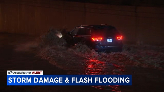
CHICAGO (WLS) -- Thunderstorms downed trees and caused flooding, travel delays and power outages in the Chicago area while some northern Illinois and Wisconsin counties are already under a Blizzard Warning on Sunday night.
ABC7 Chicago is now streaming 24/7. Click here to watch
Sunday's storms brought high winds and heavy rain, which is expected to turn into snow overnight, making for possibly hazardous road conditions during the Monday morning commute.
The first round of thunderstorms arrived in the Chicago area around 9 a.m. Sunday, and another, stronger round moved through the area from 4 p.m. to 9 p.m.
The stormy weather could be to blame for a partial house collapse on the city's South Side. Part of the top of the house, located at 69th Street and South Washtenaw, is gone.
There are no reports of injuries in the collapse. City inspectors will determine its cause.
The CTA said Red Line trains are running, but not stopping at North/Clybourn, one of the busier L stops, due to flooding.
The doors to the station were locked on Sunday night, and an employee came out and directed people to shuttle buses, because the tracks are flooded below.
The CTA also said #70 Division buses are temporarily rerouted via Division, Cicero, Augusta, Kostner and Division due to flooding near Division and Kostner.
Near Chicago Midway International Airport, several cars were stuck in high water on the Cicero ramp to Interstate 55 on Sunday night.
And there are treacherous conditions on DuSable Lake Shore Drive at 57th Street, where there is high water on the road, as well.
In the south suburbs in Riverdale and Dalton, the storms uprooted some trees. A cracked utility pole is blocking Indiana Street.
Meanwhile, ComEd is working to fix power outages. As of 8:28 p.m., ComEd said 1,410 customers are without power.
The weather has also impacted operations at Chicago's airports.
There is a Ground Delay for departures to Chicago O'Hare International Airport, with delays averaging 339 minutes due to thunderstorms. The delay is expected to last until 3 a.m. Monday.
There is also a Ground Delay for departures from O'Hare, with delays averaging 75 minutes and increasing.
As of 9:57 p.m., 1,072 flights have been canceled at O'Hare. At Midway, 122 flights have been canceled, with delays averaging 83 minutes.
This comes as there were exceptionally long lines at O'Hare's TSA checkpoints earlier Sunday. The partial government shutdown means TSA agents have not been getting paid.
Monday's snow forecast
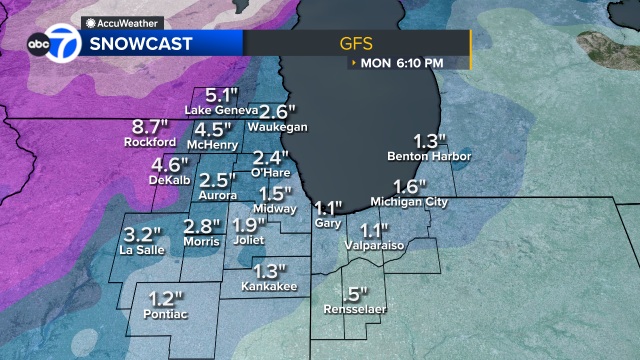
A third round of storms will move in starting at about 1 a.m. Monday, with snow falling through the morning commute until about 10 a.m.
ABC7 Chicago AccuWeather Meteorologist Greg Dutra said visibility will be low during the Monday morning drive and snow will have accumulated on the ground across the Chicago area. About 1 to 4 inches of snow is possible.
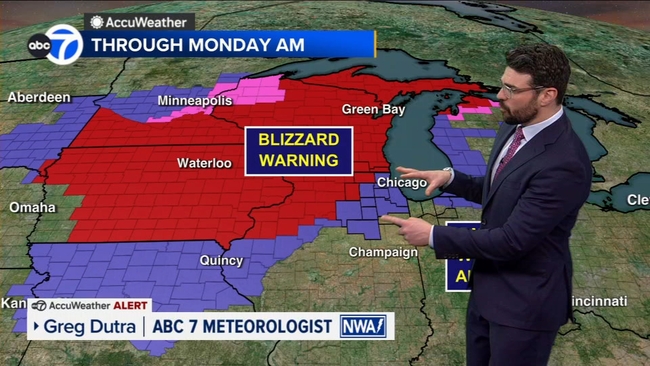
Meanwhile, a Blizzard Warning has led to a state of emergency being declared in Wisconsin and Minneapolis, and the emergency operations center has been activated in Michigan.
This is being call a historic storm, and snowfall will be measured in feet, not inches, in many places.
People are being asked to stay off the roads, and the blizzard will continue through Monday. Public offices, schools and businesses are expected to be closed in impacted areas.
SEE ALSO | School Closings: Chicago Area Complete List
Along with Wisconsin, northern Michigan and the upper peninsula are also seeing blizzard conditions. The Mackinac Bridge is closed to traffic on Sunday night.
Winds in the Chicago area will also drive feels-like temperatures down into the single digits on Monday afternoon and evening.
Active weather alerts
Wisconsin's Walworth, Kenosha and Racine counties are under a Blizzard Warning until 4 p.m. Monday.
DeKalb, Boone and McHenry counties will be under a Blizzard Warning from 10 p.m. Sunday to 1 p.m. Monday.
Cook, DuPage, Will and Lake (IN) counties are under a Flood Advisory until 2 a.m. Monday.
A Winter Weather Advisory was issued for northern Cook, DuPage, Kane, Kendall, LaSalle and Lake (IL) counties from 10 p.m. Sunday to 1 p.m. Monday.
A Winter Weather Advisory was issued for central and southern Cook, Will, Grundy and Livingston counties from 1 a.m. to 1 p.m. Monday.
LaPorte County is under a Severe Thunderstorm Watch until 2 a.m. Monday.