1 dead in NW Indiana as strong storms rip through Chicago area, downing trees and damaging homes
Semi driver killed in Valparaiso rollover; winds uproot trees, down power lines, damage homes, splitting one in half in Roselawn

CHICAGO (WLS) -- Strong storms ripped through the Chicago area on Sunday afternoon, bringing high winds and prompting tornado warnings.
At least one person was killed as high winds moved through northwest Indiana, officials said.
ABC7 Chicago is now streaming 24/7. Click here to watch
An AccuWeather Alert was in effect for an intense line of fast-moving storms that produced 80 mph winds.
Those storms, which also had the potential for damaging hail and isolated tornadoes, have since moved out of our area, well east of Interstate 65.

As of 9 p.m., 31764 NIPSCO customer were without power in northwest Indiana.
As of 3:15 p.m., 5,918 ComEd customers were without power in northern Illinois.
There was a ground delay until 9 p.m. at Chicago O'Hare Airport, where travelers experienced average delays of 33 minutes as of 4:15 p.m., the FAA said. There is an average delay of 27 minutes at Midway Airport.
Northwest Indiana saw the worst of Sunday's storms as they tracked northeast at 50-60 mph in the afternoon hours, ABC7 Chicago AccuWeather Meteorologist Phil Schwarz said.
Tree damage is obstructing some roads in Valparaiso on Sunday evening. The storms in the area caused at least one fatality, Porter County officials said.
The driver of a semi was at the property of Pratt Industries, 3050 Anthony Pratt Drive, in Valparaiso when the truck rolled over due to high winds, officials said. He was located outside of the vehicle, and he died from his injuries.
The Porter County Coroner's Officer identified the man as 34-year-old Jagbir Singh of Ontario, Canada. No further information about his death was immediately available.
An intense storm cell spawned a since-expired Tornado Warning for Lake (IN) and Newton counties.
There are no confirmed reports of tornado touchdowns in the area so far, but a tree fell on top of a house in Highland. There is no word of any injuries from the incident, which happened on 81st Street.

Winds reached 80 mph in Valparaiso, 74 mph in Gary, 70 mph in Kouts, 60 mph in Rensselaer, 52 mph in Lansing and 43 mph at Midway.
Gary saw winds up to 75 mph around 3 p.m., just as ABC7 received reports of downed trees in Roselawn.
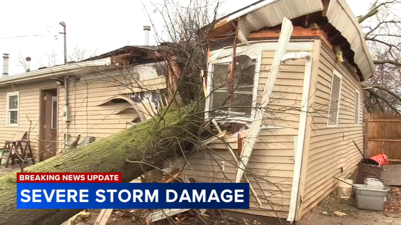
Strong winds uprooted trees, downed power lines, and damaged several homes, splitting one in half in Roselawn, on the Newton-Jasper County line.
People were shocked by just how quickly the storm ripped through northwest Indiana. At the heavily damaged home in Roselawn, a tree fell right through one of the children's bedrooms. The family said they had just 90 seconds to evacuate the house.
The Bunch family is breathing a sigh of relief tonight as they were inches away from a life-threatening tragedy.
"That's when I grabbed my sister out of her room which is right there underneath that log," Jacob Bunch said. "She's the second oldest, and we got to the middle of the house right when it hit."
Bunch said the storm was quick yet devastating as he and his family huddled in the house waiting for it to pass.
"It was a pretty intense situation, but growing up here, you gotta know these things can happen," Bunch said. "You gotta be aware, especially when you live in more rural areas surrounded by fields. It happens quick."
The Bunch family's house appeared to suffer some of the worst damage in Roselawn.
Neighbors in the area were quick to rush in and help with the cleanup.
"I was driving through here and saw some trees down," said Shawn Moody with SimpleMe Landscaping. "Asked these guys if they needed help when I saw a tree on their house. They needed help... You gotta be a human."
As the sun set on the place the family has called home for nearly a decade now, many of their belongings were also ruined. However, they're just grateful to come out of the storm unharmed.
"Top to bottom everything's done... that entire side of the house," Bunch said. "Things happen. Thankfully everyone's okay, that's all that matters."
Thankfully, no injuries were reported in the neighborhood.

Schwarz said Chicago Heights saw some weak rotation around that time as well, as very strong winds were moving through areas like Dolton, Stony Island and even up into the Englewood neighborhood on Chicago's South Side.
One storm cell with potential for strong winds was moving toward Midway Airport and Chicago's Beverly neighborhood around 3 p.m.
Other parts of the city also saw downpours around that time, but Chicago was out of the woods by 3:30 p.m., since the storms were tracking so quickly, Schwarz said.

Schwarz said the greatest threat was along and east of Interstate 57 around 3 p.m., but that threat quickly tracked northeast to along and east of I-65, across much of Porter County. The storms then moved out of our area completely, heading toward Kalamazoo and Grand Rapids.
There were some reports of hail in Frankfort and around the Illinois-Indiana state line, but the Chicago area did not see much rainfall on Sunday afternoon, due to the speed at which the storms were moving. Lake Station, for example, saw about 0.65 inches.
Most of the Chicago area was under a Level 2 risk for severe weather Sunday afternoon.
Areas farther south, like Kankakee, were under a Level 3 risk, and areas farther north, toward Wisconsin, were under a Level 1 risk.
Temperatures reached the upper-60s on Sunday, but colder air will rush in during the evening hours.
Chicago could see a few flurries early Monday with temperatures nearly 30 degrees colder.
And after a quiet day Tuesday, more rain and storms are expected Wednesday, with the possibility of severe weather.