Chicago weather: Strong thunderstorms, possible tornadoes sweep through area, causing damage | Radar
Some minor injuries in Kankakee, NW Indiana officials say


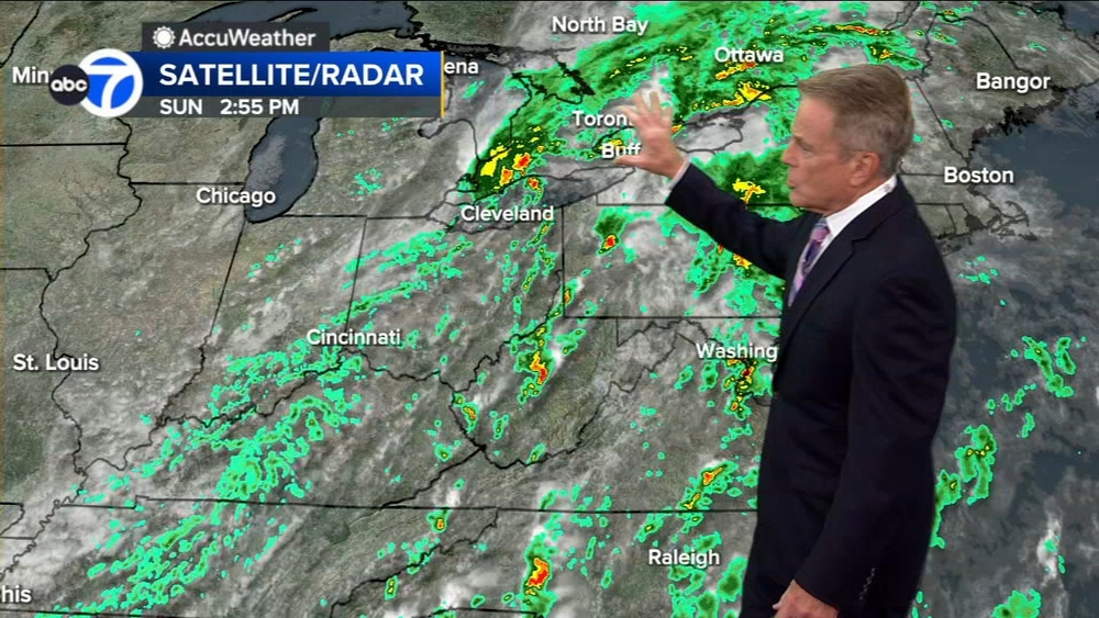
CHICAGO (WLS) -- Strong thunderstorms are sweeping through the Chicago area Tuesday afternoon, evening and into Wednesday, sparking possible tornadoes and causing damage.
ABC7 Chicago is now streaming 24/7. Click here to watch
A Tornado Watch is in effect for LaPorte County until 1 a.m. Wednesday
Tornado warnings in parts of the area have expired.
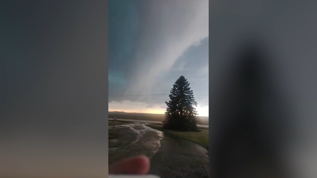
A potentially destructive tornado was seen near Wheatfield, Indiana, weather experts said.
Multiple homes and buildings have been destroyed in Lake Village, Indiana, fire officials said.
Lake Station Fire Department is serving as the staging area for all of the first responders.
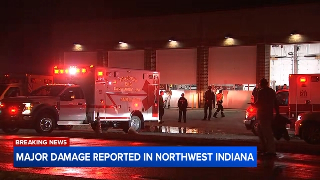
There are emergency vehicles from a number of surrounding communities.
Officials believe the damage is substantial.
They say the tornado had a wide path of destruction and continued on the ground for a couple of miles.
They are still searching for victims, who are potentially trapped underneath some of the wreckage. Only minor injuries have been reported so far.
Tornado sirens did go off in time to alert residents.
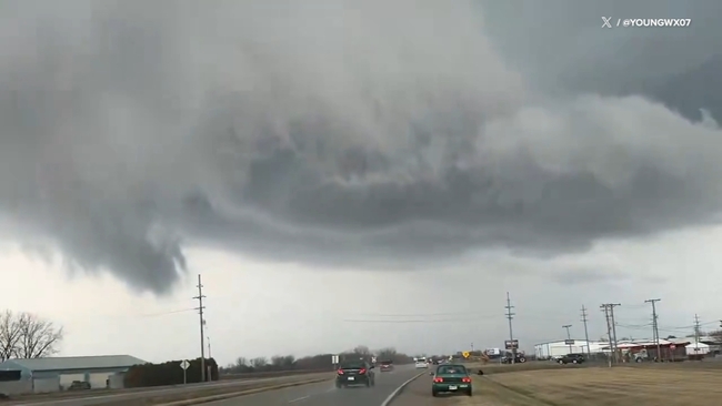
There were reports of a large and dangerous tornado near Kankakee; residents were urged to take shelter.
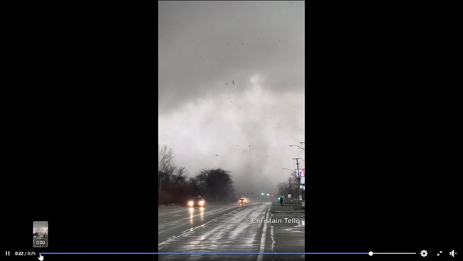
The Kankakee County Sheriff's Office said a tornado was spotted near the Kankakee County Fairgrounds.
Police said wires and trees are down throughout the county. Motorists should use caution, as cleanup efforts begin.
Extensive damage is being reported in Aroma Park, Kankakee County officials said.
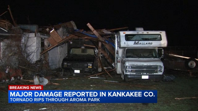
Kankakee officials said there are some minor injuries. Residents are asked to stay in their homes.
Route 45/52 is closed from River Road to Exit 308 of Interstate 57 due to downed power lines, storm damage and fires.
There is some flooding in Kankakee, as well.
One family said their windows were blown out, and a two-story barn behind the home was brought to the ground.
A concrete silo they say once stood there is gone.
Vickie Bertrand lost her husband a little over a week ago.
Bertrand doesn't live there, and her friend, Tom, who rents from her was on his way home from Momence.
She said it's a miracle no one was home.
There is a
Flash Flood Warning
for LaSalle County until midnight Wednesday.
Ground stops are in effect at both O'Hare and Midway airports until about midnight and 11:30 p.m.
Hundreds of flights have been canceled at both airports.
The National Weather Service said there was a brief tornado touchdown in Pontiac Tuesday afternoon, as well.
Pontiac fire officials said a funnel cloud with visible rotation was seen on the northern side of Pontiac
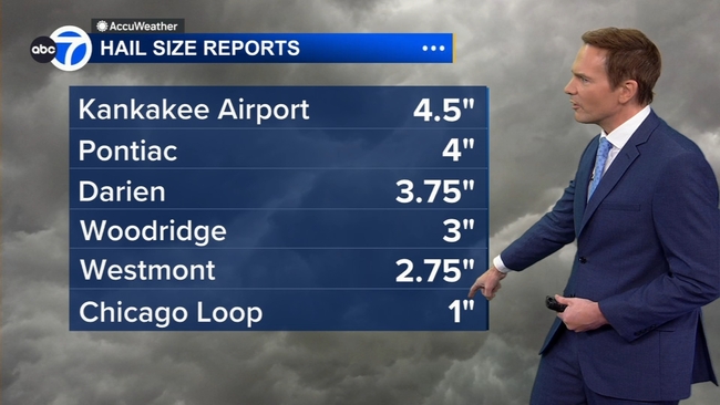
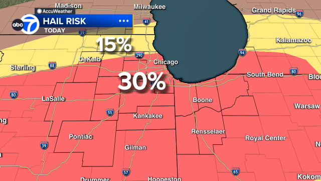
Large hail has been seen across the Chicago area.
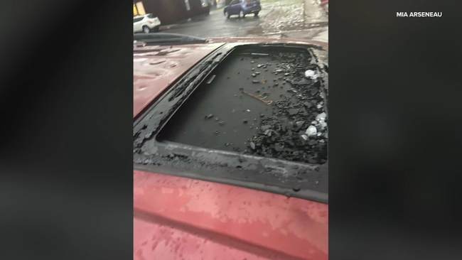
People living in Kankakee described the hail as almost as large as their hands, pounding the pavement and causing extensive damage.
"As if I have a bulletproof car and somebody was, like, shooting a machine gun, or something like that. That's how hard it was hitting," Jon Robicheaux said.
Some car windows were left shattered.
"It just kept tearing into my front windshield," Robicheaux said. "The back went out first, and it kept hitting the front. And it constantly got damaged."
He had to pull over to find shelter.
"And, I was kind of scared a tornado would've came over me while I was parked because I couldn't see anything," Robicheaux said.
Some cars in the west suburbs were damaged, as well, after golf ball- to baseball-sized hail fell.
One large chunk of hail came down on Gabrielle Zinkel's car as she was driving home to Homer Glen from work in Downers Grove, shattering her back windshield.
"It sounded exactly like bullets hitting your car. Like, I was like, did my windshield just get shot through? Like what just happened? Because I did not think. I was like, OK, I'm going to come through this with some dents. But I didn't think that this thing would hit my windshield and crack it right open," Zinkel said.
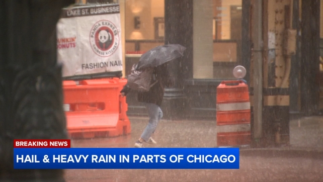
There was also heavy rain and hail in parts of the city.
The hail sent people scrambling around dusk.
As of 9 p.m., nearly 8,000 ComEd customers are without power and nearly 4,600 NIPSCO customers are without power.
The highest risk time for severe weather began at about 4 p.m. and continues through midnight.
Main threats from the storm include large hail, damaging winds and flash flooding, with the main tornado threat for areas south of Interstate 80.
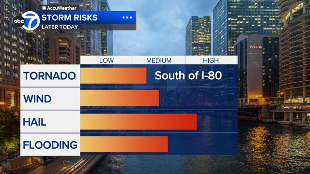
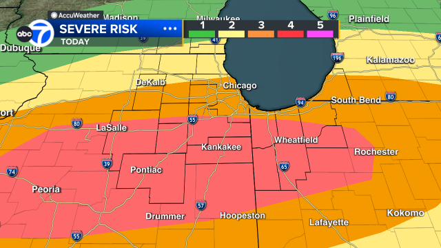
Areas along I-80 and south are at a Level 4 risk for severe weather.
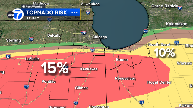
The probability of a tornado risk along I-80 and south has been increased to 15%.
A Flood Watch is in effect until 3 a.m. Wednesday for Cook, DuPage, Will, Grundy, Kane, Kankakee, Kendall and LaSalle counties.
Most of Chicago, including the south and southwest suburbs, was placed under a Level 3 risk.
The north and northwest suburbs are under a Level 2 risk.
STAY ALERT | Download the ABC7 Chicago app to get latest weather alerts