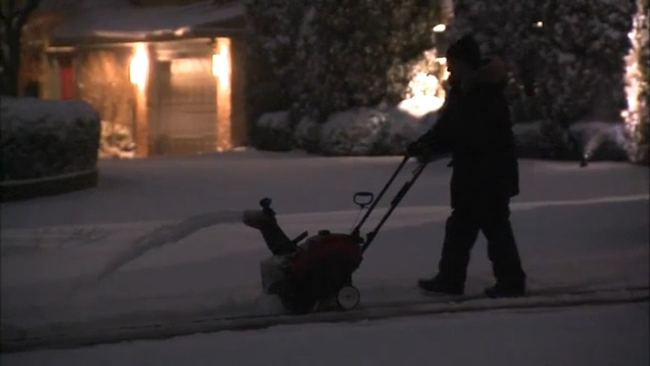
Chicago snowstorm forecast to bring upwards of 5 inches along Lake Michigan
Winter Storm Warning in effect for Chicago area


CHICAGO (WLS) -- The Chicago area is beginning the new year with a winter storm that is expected to bring upwards of five inches of snow in some places.
The National Weather Service has upgraded the Winter Storm Watch to a Winter Storm Warning for Boone, Cook, DeKalb, DuPage, Grundy, Kane, Kendall, La Salle, Lee, McHenry, Ogle, Will, and Winnebago counties that took effect Saturday morning and continue through early Sunday morning.
Most areas will see snow accumulations in the 3 to 5-inch range, though areas near Lake Michigan could end up with more due to lake enhancement and lake effect snow showers, according to ABC7 Meteorologist Phil Schwarz. The city will likely see more than five inches.
In response to the storm, the Chicago Department of Streets and Sanitation said it's deploying 211 salt spreaders. The salt spreaders will focus on addressing ice and snow along the city's arterial routes and Lake Shore Drive, the department said in a release.
"I was like, let me make a run and as soon as I looked out the window I said maybe not," said Chicagoan Rob Robinson.
Just hours into 2022 brought snow and ice, blanketing the city as drivers try to make it to their destination with little concern.
"It's pretty windy, but as long as you're prepared and have layers on, it's not too bad," said fellow Chicagogan, Kendall Junger.
Winds will gust up to 35 mph on Saturday night as another few inches accumulate, creating blowing snow and poor visibility. Snow accumulations will reach three to six inches, contributing to the dangerous travel conditions.
"Hopefully, it doesn't get much worse in the meantime," added Ben Clay, who was driving to Wheaton. "Take it a bit slow. Leave some distance between the guy in front of you."
The snow will end between 1 a.m. and 6 a.m. Sunday, but a band of lake effect snow will impact the city and parts of Lake County (IL), Cook County and even eastern DuPage County. Another couple of inches will be possible in these areas.
"I miss it. I like having all four seasons, so it's nice to kind of feel a little bit like the holidays have finally started even though they're ending," Junger said.
Winds will stay gusty as temperatures fall into the teens overnight Saturday, so expect roads to remain in poor condition into Sunday morning, Meteorologist Greg Dutra said.
Between 6 a.m. and 1 p.m. Sunday, the lake effect snow band will shift into northwest Indiana before moving into southwest Michigan in the afternoon.
The Chicago area saw its first measurable snow of the season Tuesday after one of the longest snow droughts in the city's history.