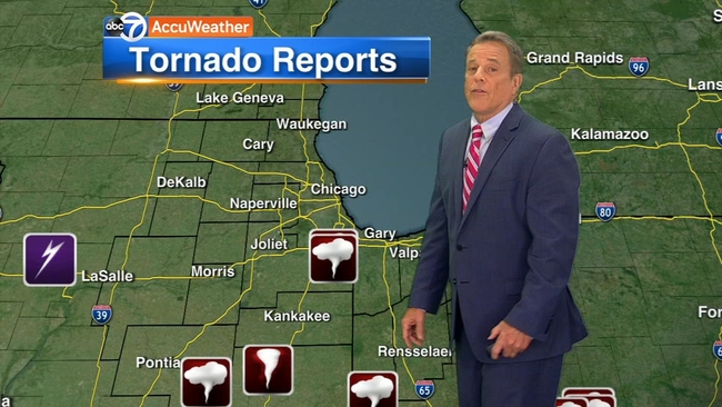
4 tornadoes confirmed in, near Chicago area during weekend severe storms, NWS says
Flooding reported across city, suburbs as storms dump several inches of rain


CHICAGO (WLS) -- Storm surveys confirmed the weekend's severe weather produced four tornadoes in and near the Chicago area, according to the National Weather Service.
A line of severe storms prompted several tornado warnings Saturday.
The survey indicated an EF-1 with peak winds of 95 mph in Danforth in Iroquois County on Friday.
Three EF-0s with winds between 70-80 mph were recorded Saturday in Crete in Will County, Chatsworth in Livingston County (IL), as well as in Dyer/Schererville in Lake County (IN).
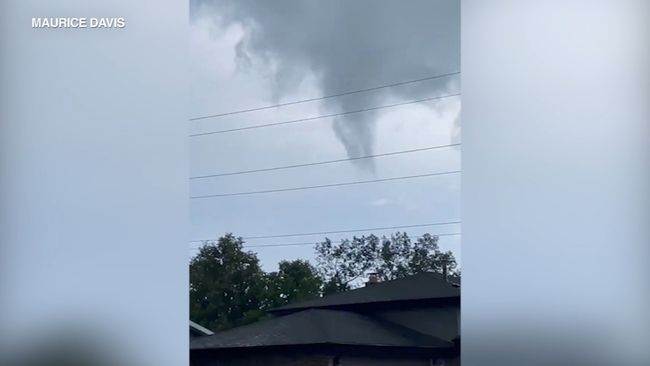
Tornado sirens went off twice in south suburban Crete Saturday afternoon. The first time was around 2 p.m. when a tornado was spotted going through town. Cell phone video captured by Crete Firefighter William Eberhardt showed a well-formed funnel cloud, although no touchdown was confirmed.
"I looked at it at first and it was just rotating slowly and it was gradually getting bigger, and it looked like it was going to touch down there for a second," Eberhardt said. "Then it went right back up to the clouds and just dissipated."
WATCH: Viewer captures video of funnel cloud in Crete
ABC7 Meteorologists Phil Schwarz and Greg Dutra analyzed radar that showed velocity and rotation data that indicated a possible tornado near Crete just after 2 p.m. Saturday. The system then appeared to move near Dyer.
The National Weather Service had previously confirmed a tornado was over Crete and Steger and moved northeast at 30 mph just after 2 p.m. Saturday.
It was moments after speaking to Eberhardt, at around 4:15 p.m. that the sirens went off again when a second funnel cloud sighting sent our ABC7 crew into the fire department's emergency shelter until the danger passed.
ABC7 crew rushes for shelter during tornado warning
Despite multiple alerts, the violent storms left behind mostly tree damage, and at least one injury was reported in nearby Steger, where a woman was hit by a falling tree.
"We heard a big snap and we looked over and a huge 60-foot tree is falling and the neighbor's wife was underneath it," said witness Marc Opyt. "We ran over [and] we called 911 and we pulled the branches off her. [We] held the branches back so they wouldn't push up against her until they took her out."
The woman was taken to the hospital with a possible broken leg.
Meanwhile, across the border in Indiana, torrential rains and strong winds also caused severe tree damage.
Similar activity was seen in northern portions of Newton and Jasper counties, as well as Lake and Porter counties. There are also unconfirmed reports of a tornado or microburst in the Hoosier State, but no reports of injuries there so far.
A funnel cloud was reported by emergency management officials near Earl Park in Benton County, Indiana around 6:15 p.m., according to the NWS.
"Storm just blew through out of nowhere, came through and knocked over all our trees," said Nancy Phillips, a Dyer, Indiana resident.
"All of a sudden I heard a train, and you always hear it sounds like a train, so I knew. But it was very, very quick. We were lucky no one in the neighborhood was hurt,"added fellow resident Jill Brouillette.
Funnel clouds reported in Chicago suburbs
A funnel cloud was also spotted near W Goodenow Rd, north of Beecher in Will County (IL) at 4:32 p.m., according to the National Weather Service.
NWS Chicago said more details on the path, length and width of each tornado will be released as soon as it is available.
2 tornadoes confirmed in northern central Indiana
The National Weather Service has confirmed two tornados touched down in north-central Indian.
According to WTHR-TV, the first tornado was reported around 8:18 p.m. Friday night in far eastern Tippecanoe County at winds of 95 mph. At around 8:30 p.m.
Friday, reports were made of a second tornado in Carroll County. Reports of damage in Carroll County included mainly tree damage and some minor shingle or siding damage to homes, but there were no reports of any injuries.
The Associated Press contributed to this article.