Chicago weather: Winter Storm Warning in effect for several suburban counties


CHICAGO (WLS) -- Two rounds of wet snow and rain are expected to hit the Chicago area on Monday and Tuesday nights, according to ABC7 Chicago meteorologists Jaisol Martinez and Greg Dutra.
Chicago could see 2 to 6 inches of total precipitation through Wednesday morning. The western suburbs could see 3 to 7 inches, and the far western areas could see 4 to 9 inches.
ABC7 Chicago is now streaming 24/7. Click here to watch
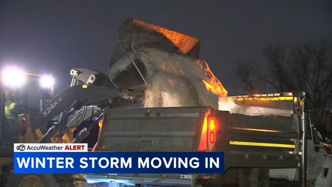
Wet, heavy snow and gusty wind could lead to issues on the roads. The Chicago Department of Streets and Sanitation said more than 200 salt spreaders will be on the city's streets, focusing on arterial routes and DuSable Lake Shore Drive.
A Winter Storm Warning went into effect at 8 p.m. Monday for Winnebago, Boone, McHenry, Lake, Ogle, Lee, DeKalb, Kane and LaSalle counties, the National Weather Service said. It is set to expire at midnight on Wednesday.
A Winter Weather Advisory also went into effect at 8 p.m. Monday for Cook, DuPage, Grundy, Kankakee, Kendall, Livingston, and Will counties. It is set to expire at noon Tuesday. The advisory will be in effect for Boone, DeKalb, Kane, Lake, LaSalle and McHenry counties from 8 p.m. Monday until 6 p.m. Tuesday.
A Winter Storm Watch for Boone, McHenry, Winnebago, Ogle, Lee and DeKalb counties will be in effect from 6 a.m. Tuesday to 3 a.m. Wednesday, NWS said.
The first round of snow is expected to begin late Monday night into early Tuesday morning. A second wave is expected to begin late Tuesday afternoon and into the night, according to ABC7 meteorologists Jaisol Martinez and Greg Dutra.
SEE ALSO | Some Amtrak trains canceled ahead of possible Chicago snow storm
The first round is expected to arrive between 8 and 10 p.m. Monday, and could bring between 1 and 3 inches of precipitation to the city. It will transition into a rain/snow mix throughout the Tuesday morning commute between 7 and 10 a.m. Areas south of Chicago are expected to get the heaviest of the wet snow.
ABC7 meteorologist Tracy Butler said the second wave is expected to have a sharp cutoff in the amount of snow due to the element of rain.
On Tuesday evening, most of the area will see snow between 7 and 9 p.m. Light snow is expected steadily from 3 to 5 a.m. Wednesday.
The highest precipitation totals from the Tuesday night round are expected west of Chicago, especial toward McHenry, Kane, LaSalle and DeKalb counties. It could bring an additional 1 to 3 inches of precipitation to the city and an additional 2 to 4 inches for the western suburbs.
For the second round, areas in and round the city could see an additional 1 to 3 inches of snow, with western suburbs seeing between 3 to 5 inches of additional snow and areas to the far west seeing between 5 to 8 inches of snow. Northern Indiana may see up to an inch of additional snow.
Ahead of the first round, Chicago Streets and Sanitation Commissioner Cole Stallard said the severity of the storm's impact could depend on whether ground temperatures stay above or below freezing.
"We're going to bring our folks in about 9 o'clock tonight. We're going to really take a hard look at this to see if we got to up it for that morning rush," Stallard said. "It looks like we're going to see some kind of precipitation for 30 hours, so we're going to watch those temperatures and those grounds temps are something we'll be closely monitoring."
On Tuesday morning, ComEd will open its emergency operations center. The utility has been mobilizing extra crews, anticipating power outages that could be made worse by the type of snow expected this week.
"When you have wet, heavy snow you can see power lines come down. You can also see branches laying on power lines. We want to make sure that the public is aware to stay away from any lines that, they may see that are down," said Nichole Owens, ComEd vice president of Electric Distribution Operations.
At hardware stores, including JC Licht Ace Hardware in the Gold Coast, people have been snapping up the staples, including shovels, salt and snow blowers. This first significant snowfall of the season is coming after a relatively dry winter last year.
"We're seeing people that haven't tested their snow blowers, and now they need to get them repaired, so we're going to do that, as well, so we have a whole team ready for the repairs of the snow blowers. So, it's going to be a little bit of everything for people that did wait for the last minute because, again, it's been 13 months since we've really had anything big here," said Jeremy Melnick, with JC Licht Ace Hardware.
Stallard issued a warning to take it slow on the roads as city salt trucks were prepped, loaded and ready to hit the streets for what could be a busy 48 hours.
"Talk to those young drivers. Everybody's back in school. Get that message out to those young kids driving in to high school for the first time and seeing snow. Have that conversation when you're sitting around eating dinner tonight," Stallard said.
Salt trucks were prepped and loaded on Monday night in Calumet City, ready to clear the city's 55 miles of pavement.
Calumet City Public Works Commissioner Jericho Thomas said the expected rain could wash away efforts to salt.
"We want to make sure we're salting the roads out, and then we want to make sure we're taking care of our police and fire department and our emergency buildings, too, as well," Thomas said. "Just spread as much as possible. Never give it a limit when the temperatures drop."
Trucks were also loaded up with salt to spread over 136 miles in Elk Grove Village.
While they have had a couple of so-called snow events so far this season, the forecast for Monday night will be the first significant snowfall, and they are ready.
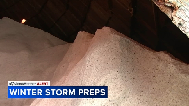
"We are 100% loaded and ready to go. Our guys are coming in the middle of the night and will be ready for whatever happens," Elk Grove Public Works Director Colby Basham said. "We used about half the amount of salt last year as normal, but we start the season full so our salt barns are full right now."
The village has a snow command center to keep up with the forecast and keep track of the location of plow trucks and help direct them to where they are needed.
The trucks are loaded and ready to go in the garage. They have had plenty of time to do vehicle checks, calibrate the salt spreaders and get them ready for service.
By this time of year, the Chicago area typically has already had a couple serious winter storms. But it has not this year. In fact, last winter was relatively mild, as well, so crews are ready to get to work.
In Aurora, they are hooking up plows to some of the other trucks in the fleet, getting ready for what looks to be a busy week.
"We got a complete week of one type of snow removal depending on how heavy it comes in, so it'll be our busiest week of this season," Aurora Streets Superintendent Tim Forbes said.
Many communities are putting snow removal crews on 12-hour shifts starting Monday. They will be busy.
"That is something our guys take a lot of pride in because they know they're 100% needed for these events," Basham said.
You can find a full list of school closures here.