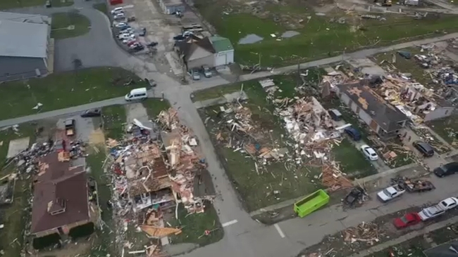
At least 7 tornadoes reported in Indiana, causing widespread damage across the state, NWS says
Roofs ripped off homes in Northwest Indiana as widespread storm damage reported in Chicago area


CHICAGO (WLS) -- A severe weather event tore through Indiana Friday, leaving a wake of destruction behind.
At least seven tornadoes, ranging from ER-0 to EF-3, have been confirmed in Indiana, the National Weather Service said Saturday.
WATCH | Drone video shows the devastating aftermath of destructive storms and tornadoes in Whiteland, Indiana
An EF-3 was reported on Sillivan County, with peak winds of 115 MPH.
Two tornadoes were reported in Johnson County. An EF-2 with peaks winds of 135 MPH hit Whiteland, as well as an EF-0 with peak winds of 85 MPH south of Bargersville.
Three tornades were also reported near Howard County. Two EF-0 tornadoes with peak winds of 80 MPH touched down in Southwest Howard County, and an EF-1 with peaks winds of 110 MPH was reported in Southeast Howard County.
An EF-1 with peak winds of 110 MPH also struck Clinton County.
Another severe weather threat is expected to move through Central Indiana Tuesday, NWS said.
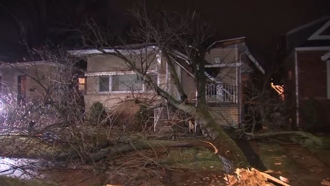
The storm also brought powerful winds that uprooted trees,shattered window and ripped the roods off homes Friday in Merrillville, Indiana.
Residents assessed the damage overnight as the weather subsided. They told ABC7 it could take them weeks or months to repair their homes.
"It's gonna be a lot of work," said Merrillville resident Torrona Tillman. "Life has changed."
Heavy rain and wind speeds upwards of 75 mph ripped through the neighborhood, forcing many to seek shelter or evacuate.
"We were all kind of lounging around. Next thing you know, it kind of just sounded like a train crashed in the street. It was very loud, very aggressive. It shook the whole house," said Michae Harris, another resident.
Garage doors were crumbled by fierce winds. Several homes sustained damage inside and outside, with windows smashed and fences torn to the ground also smashed.
MORE | Get the latest AccuWeather alerts here
"We came and looked, and we had no garage," Tillman said.
Much of that debris was left scattered throughout neighborhood yards. Tillman and her husband were joined by neighbors on Saturday to begin the clean up process, with the front of their home substantially damaged.
"Stuff like this, acts of God, you can't really control that. It just makes you feel comfortable seeing communities come together," she said.
The Red Cross is now helping those residents in what will be a lengthy recovery.
An officer on the scene told ABC7 that some homes in Merrillville had gas lines burst from the storm. Nipsco Power came in and shut off gas lines around 9:15 p.m. Friday. No one was injured, but people were evacuated.
"They made everybody leave out their houses last night because there was so much gas in the air, gas lines," said Gregory, who is visiting his brother in Merrillville.
Nipsco told ABC7 more than 12,000 people across Northwest Indiana remained without power as of 8 a.m. Saturday. That number was as high as 18,500 at its peak.
Indiana State Police said four semis were blown over on I-65 near the exits for Remington and Lowell. There are extensive closures on I-65 southbound, and drivers should avoid the area.
Illinois State Police said troopers responded to multiple overturned vehicles on I-57 near Rantoul in Champaign County downstate, which were blown over by strong winds from the storms. Three people were taken to a local hospital with non-life threatening injuries, state police said. There are also downed power lines across the interstate. I-57 will be shut down for several hours for cleanup and traffic is being diverted at northbound exit 250 and southbound exit 261. Drivers should avoid the area.
CHICAGO WEATHER
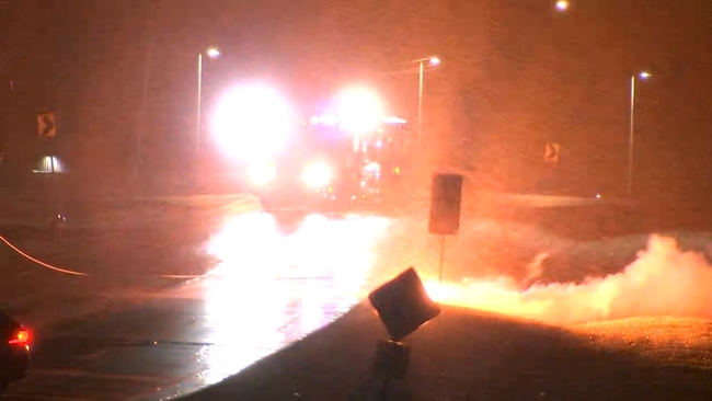
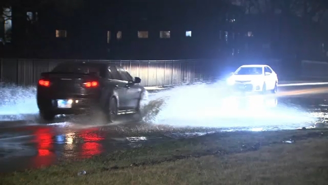
Nearly the entire Chicago area was under some type of severe weather warning or watch Friday night as a line of intense storms raced through the area, leaving damage and flooding in their wake.
The National Weather Service warned of a "particularly dangerous situation" with the potential for intense tornadoes to develop across Iowa and Illinois Friday morning, a prediction which has largely come to pass. The NWS said the severe weather threat was officially over as of 10:35 p.m.
One person was killed and 40 people were injured during the severe weather outbreak in Illinois Friday when the roof collapsed at the Apollo Theatre in far northwest suburban Belvidere.
An EF-1 tornado was confirmed in the Davis Junction-Belvidere area, NWS said Saturday. The tornado traveled nearly 28 miles across portions of Ogle, Winnebago and Boone counties within just 25 minutes, with peak winds of 100 MPH and a max width of 900 yards, NWS said.
In Chicago, ComEd said 29,104 customers were without power as of 4:30 a.m. Saturday. Crews are working to restore power as quickly as possible.
Air travel in Chicago was also affected by the severe weather. There was an FAA-issued ground delay until 11:59 p.m. Friday, with an average delay of 233 minutes due to thunderstorms. Those issues lessened going into Saturday morning, with average delays at Midway and O'Hare under 20 minutes.
Metra BSNF line trains to Aurora were stopped for a time due to high winds. The transit agency warned that Union Pacific trains including the West, Northwest and North lines may have to stop due to high winds in the area, and may also need to travel at reduced speeds.
The high winds brought a tree down on a house in Chicago's Mt. Greenwood neighborhood, at 103rd and Lawndale. The tree was sheared in multiple places and fell up the walkway onto the patio area and roof of the home. It did not appear anyone was injured, and lights were seen on inside the home even as the entrance was blocked by the fallen tree.
In the southwest suburbs, 71 mile per hour wind gusts were clocked in Joliet as the storms blew through, but as of 10 p.m. things were calm and there did not appear to be many tree branches down or power outages.
Aurora officials reported multiple downed power lines. Across Deerpath Road they sparked and spit fire, though no injuries were reported. Officials are strongly cautioning people to stay in their homes if their power is out; not all downed power lines are easily visible but they are still dangerous.
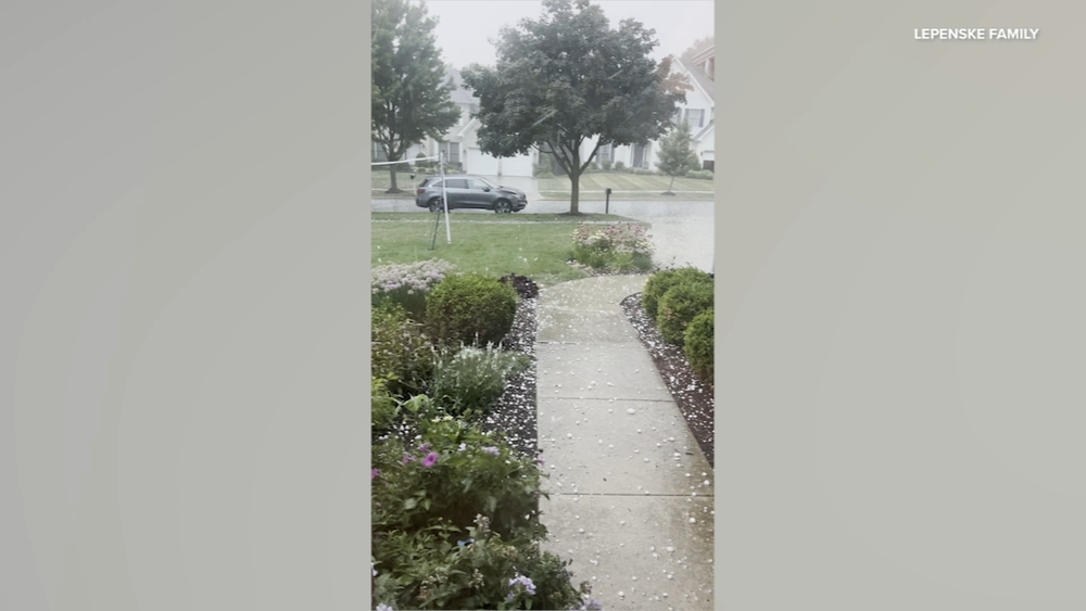
In west suburban Wood Dale, hail rained down and sudden downpours caused extensive flash flooding.
Gusts of winds were so strong that at one gas station, the pumps seemed for a moment to be on the verge of going airborne, and trash cans and other unsecured items were pushed around and into drivers' paths.
There were large areas of standing water, largely where main streets intersect with side roads, though by 10 p.m. water had started receding. Some of the standing water appeared to be about a foot at its deepest point. Officials caution drivers not to drive through standing water, even if it looks shallow.
The same kinds of flash flooding were also reported in neighboring Addison and Wheaton.
In south suburban Flossmoor, one resident reported the downpour flooded her backyard in just half an hour.
How rare are tornadoes in the Chicago area?
According to the NOAA Storm Event database, there have been approximately 61 tornadoes in Cook, Du Page, Kane, Lake (IL), McHenry and Will counties in the last 10 years that directly led to 12 injuries.
The largest of those tornadoes was an EF-3 that struck Naperville and Woodridge on June 20, 2021.
The largest tornado to hit Cook County since 1950 was an F-4 that struck Oak Lawn and the South Side of Chicago on April, 21, 1967. It directly led to 33 deaths, 500 injuries, and an estimated $25 million in property damages. It is the deadliest tornado in Cook and the collar counties since 1950.
The largest tornado recorded in Cook and the collar counties since 1950 struck Plainfield in Will County on August 28, 1990 (F-5). It directly led to 29 deaths, 350 injuries, and an estimated $250 million in property damages.
Stay tuned to ABC7 Eyewitness News and abc7chicago.com for the latest updates on the potentially severe weather.