Chicago weather: Winter Storm Warning issued for much of area, with several inches of snow expected
Storm expected to move in early Friday morning


CHICAGO (WLS) -- The Chicago area is bracing for a major winter storm set to begin moving in early Friday morning.
A Winter Storm Warning is in effect from 3 a.m. Friday until noon Saturday for Grundy, Kendall, LaSalle, eastern Will, northern Will, southern Cook, southern Will, central Cook, Lake, northern Cook, DuPage, Kane, McHenry, Boone, DeKalb, Lee, Ogle and Winnebago counties in Illinois.
ABC7 Chicago is now streaming 24/7. Click here to watch
A Winter Storm Watch is in effect from 6 a.m. Friday until noon Saturday for Kankakee County in Illinois and Lake and Porter counties in Indiana.
A Winter Weather Advisory is in effect from 3 a.m. Friday until noon Saturday for Kankakee County in Illinois and Lake and Porter counties in Indiana. The advisory starts at 6 p.m. Friday for Benton, Jasper and Newton counties in Indiana.
Wisconsin's Racine, Kenosha and Walworth counties were upgraded to a Winter Storm Warning Thursday afternoon, lasting until noon Saturday.
ABC7 Chicago meteorologist Larry Mowry said the snow will begin between 3 and 9 a.m. Friday, and 1 to 4 inches are possible then.
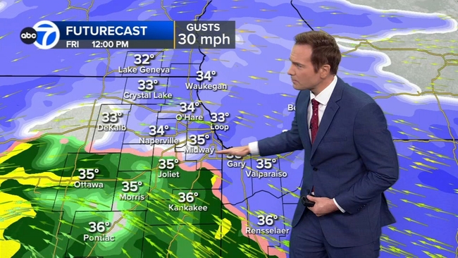
There could be bursts of heavy snow, with 1 to 2 inches per hour briefly possible.
"Please, people, use caution; we are going to be there to take care of you and get you where you need to go," Metra spokeswoman Meg Thomas-Reile said.
Metra said it will have extra staff on-deck, with rotating shifts to help clear the way for commuters.
"We are starting working on our platforms, pre-salting and everything, and then, at midnight tonight, we'll have crews starting that, and they just go in rotation," Thomas-Reile said.
RELATED: At least 5 dead across country as sprawling storms wallop US
From 9 a.m. to 3 p.m., snow will continue for areas west and north and likely in central Cook County.
The worst part of the storm will be from 3 p.m. to midnight, as snow rates pick up to 1 to 2 inches per hour, especially between 5 and 8 p.m. Winds will also increase to 40 mph.
From midnight to 8 a.m. Saturday, the snow intensity will drop off, but blowing and drifting snow will be an issue.
Light snow will continue Saturday, with high winds.
Chicago's northwest suburbs, including northern Kane, DeKalb, McHenry, Lake and far northwest Cook counties could get 8 to 12 inches of snow or more, Mowry said.
DuPage County, central and south Cook County, Joliet and Morris could get 6 to 8 inches of snow.
Areas south of Interstate 80 will likely get 3 to 6 inches of snow, as will areas in and around the city.
Winds are expected to be blowing from the east, which may cut down on snow totals in areas near Lake Michigan.
The Chicago Office of Emergency Management and Communications warned of possible blizzard conditions Friday night into early Saturday.
The Chicago Department of Streets and Sanitation (DSS) has salt spreaders out on city streets, monitoring conditions on arterial routes, DuSable Lake Shore Drive, as well as city bridges and overpasses, to ensure roads are safe and passable for emergency vehicles, public transportation and other travelers, OEMC said.
Snow removal companies say their crews were resting Thursday night because, in a few hours, they would be busy, especially in the north and west suburbs.
The snow removal will just be the first hurdle for many.
A bitter cold will arrive Sunday, with highs in the single digits. Wind chills will drop below zero Sunday afternoon and likely stay there until Wednesday.
"Stocking up before what's expected to be a big snowfall across our area," said Gio Tsiagalis, who was leaving a Roselle hardware store Thursday with a brand new snow blower.
"I woke up, and my phone said 12-18 inches coming by my house, and I'm like, you know, I've been putting off buying a snow blower for about the last seven years. I think that's a sign it's finally time to get one," the Lombard resident said.
Max Kaiser was picking up cycle oil for his snow blower, so he can steer clear of having to use his shovel.
"There's no way I'm shoveling all that snow, so it got to be, I got to use the snow blower," said Kaiser, who lives in Roselle.
ComEd said the inches of snow expected to fall could mean power outages.
"We've got people in place that are ready to respond if we start to see customer impact from the storm," ComEd spokesman John Schoen said.
But the second challenge will be the anticipated temperature drop that comes after the snow.
"So that could lead to things like tree branches falling on the line and whole trees toppling onto the line, so that makes things potentially trickier," Schoen said.
ComEd is reminding customers that, if an outage does occur, let them know right away.
Also, those clearing away snow should not pile it on or near utility equipment, so, if there is an outage, it will be easier for crews to fix.
Weather Alerts Live Doppler Radar
Cook County Radar DuPage County Radar Will County Radar Lake County Radar (IL) Kane County Radar Northwest Indiana Radar
Related Topics
- TRAVEL
- CHICAGO
- O'HARE
- MIDWAY AIRPORT
- COOK COUNTY
- KANE COUNTY
- KENDALL COUNTY
- WINNEBAGO COUNTY
- WILL COUNTY
- GRUNDY COUNTY
- KANKAKEE COUNTY
- OGLE COUNTY
- LEE COUNTY
- LASALLE COUNTY
- LAKE COUNTY
- LAKE COUNTY INDIANA
- LA PORTE
- MCHENRY COUNTY
- BOONE COUNTY
- DEKALB COUNTY
- PORTER COUNTY
- WISCONSIN
- WINTER STORM
- WEATHER
- WINTER
- WINTER WEATHER
- SNOW
- SNOW STORM
- AIR TRAVEL
- O'HARE AIRPORT
- MIDWAY AIRPORT
- AIRPORT NEWS