AccuWeather


- Severe Thunderstorm Warning
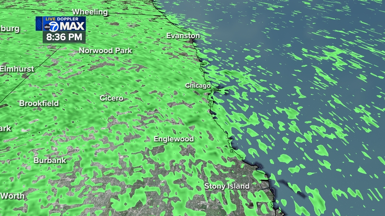
At 1019 PM CDT, severe thunderstorms were located along a line extending from East Garfield Park to Dolton, moving northeast at 30 mph. HAZARD...60 mph wind gusts and penny size hail. SOURCE...Radar indicated. IMPACT...Expect damage to roofs, siding, and trees. These severe storms will be near... Chicago, Hammond, Calumet City, West Town, Bridgeport, Englewood, Lake View, Lincoln Park, Chicago Loop, and South Shore around 1025 PM CDT. Other locations impacted by these severe thunderstorms include West Lawn, Orland Hills, West Garfield Park, Oakland, West Elsdon, Beverly, East Side, Riverdale, Lower West Side, and McKinley Park.More
- Special Weather Statement
At 957 PM CDT, Doppler radar was tracking strong thunderstorms along a line extending from Hodgkins to near Oak Forest to near Monee. Movement was northeast at 30 mph. HAZARD...Wind gusts of 50 to 55 mph and nickel size hail. SOURCE...Radar indicated. IMPACT...Gusty winds could knock down tree limbs and blow around unsecured objects. Minor hail damage to vegetation is possible. Strong thunderstorms will be near... Chicago, Cicero, Tinley Park, Oak Lawn, Berwyn, Oak Park, Chicago Heights, Midway Airport, Austin, and South Lawndale around 1005 PM CDT. Roseland, Englewood, Dolton, Humboldt Park, Brighton Park, Chatham, New City, Auburn Gresham, East Garfield Park, and River Forest around 1010 PM CDT. Calumet City, West Town, Bridgeport, Lansing, Belmont Cragin, Logan Square, Near West Side, and South Deering around 1015 PM CDT.More
- Severe Thunderstorm Warning
At 1019 PM CDT, severe thunderstorms were located along a line extending from East Garfield Park to Dolton, moving northeast at 30 mph. HAZARD...60 mph wind gusts and penny size hail. SOURCE...Radar indicated. IMPACT...Expect damage to roofs, siding, and trees. These severe storms will be near... Chicago, Hammond, Calumet City, West Town, Bridgeport, Englewood, Lake View, Lincoln Park, Chicago Loop, and South Shore around 1025 PM CDT. Other locations impacted by these severe thunderstorms include West Lawn, Orland Hills, West Garfield Park, Oakland, West Elsdon, Beverly, East Side, Riverdale, Lower West Side, and McKinley Park.More
- Special Weather Statement
At 957 PM CDT, Doppler radar was tracking strong thunderstorms along a line extending from Hodgkins to near Oak Forest to near Monee. Movement was northeast at 30 mph. HAZARD...Wind gusts of 50 to 55 mph and nickel size hail. SOURCE...Radar indicated. IMPACT...Gusty winds could knock down tree limbs and blow around unsecured objects. Minor hail damage to vegetation is possible. Strong thunderstorms will be near... Chicago, Cicero, Tinley Park, Oak Lawn, Berwyn, Oak Park, Chicago Heights, Midway Airport, Austin, and South Lawndale around 1005 PM CDT. Roseland, Englewood, Dolton, Humboldt Park, Brighton Park, Chatham, New City, Auburn Gresham, East Garfield Park, and River Forest around 1010 PM CDT. Calumet City, West Town, Bridgeport, Lansing, Belmont Cragin, Logan Square, Near West Side, and South Deering around 1015 PM CDT.More


